«Missouri River • Great Plains • Rocky Mountains» | «Radio • Writs • Ride • Resources»
Rocheport's public basketball court underwater.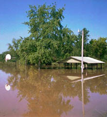
06/08/2001: Rocheport, MO |
Short or Long? The route was arduous, with us relying on limited and downright inaccurate geographical information. And more damn bicycle portaging. Whiskey was scarse; affable and talkative people weren't. My observations, to this point, leave something to be desired -- at least by me. Perhaps I haven't had time to make much sense of this place, perhaps I haven't had much inclination to do so... But there are strange social strata and cultural frictions at odds with each other here. It strikes me as unusual how people seem to have some sense of the past without having any idea about what's going on between themselves now. To which I have to admit a tremendous bias *against* the midwest. It is no secret the disdain I have for the area and, in awfully general terms, its denizens... But enough vitriol for now. |
«Missouri River • Great Plains • Rocky Mountains» | «Radio • Writs • Ride • Resources»
©2001 Barrett Golding / Josef Verbanac
![]() Funding from the Corporation for Public Broadcasting
Funding from the Corporation for Public Broadcasting