«Missouri River • Great Plains • Rocky Mountains» | «Radio • Writs • Ride • Resources»
Campground host Farrell Atkins at Arrow Rock State Park.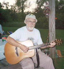
06/10/2001: Arrow Rock, MO |
Bonesaws & Whiskey At least I hope so. Planning routes this eve, trying to find some way, like a tesseract, that brings us magically closer to omaha... A relatively short day of riding, but strenuous. The next week will be long, hot days bringing us closer to the upper missouri -- that stretch above souix city, ia, where the river bottom retains something akin to its earlier width and speed, prior to the manipulations and contortions which constrained it to make it more ammenible to barge traffic. Light fading and mosquitoes attacking -- enough for the time being... |
«Missouri River • Great Plains • Rocky Mountains» | «Radio • Writs • Ride • Resources»
©2001 Barrett Golding / Josef Verbanac
![]() Funding from the Corporation for Public Broadcasting
Funding from the Corporation for Public Broadcasting