2008-06-05
The NY Times map of “Where the Candidates Found Support” provides one of the more interesting views of the Democratic primary race. Note how Clinton won a swath of the country (from north Texas to upstate New York that you could term Trans-Appalachia. Obama, meanwhile, took the everything on the other side of them thar hills, which happened to be both more heavily populated and more African-American. But I think it’s interesting too how he picked up all of the predominantly white Northwest too.
“Demography trumps everything” sez David Runciman in the latest London Review of Books, “The Cattle-Prod Election:”
“But viewed in retrospect, it is clear that it has been quite predictable. All the twists and turns have been a function of the somewhat random sequencing of different state primaries, which taken individually have invariably conformed to type, with Obama winning where he was always likely to win (caucus states, among college-educated and black voters, in the cities), and Clinton winning where she was likely to win (big states with secret ballots, among less well-educated whites and Hispanics, in rural areas). Even the initial drama of that week in early January – when Obama’s victory in Iowa had seemed to give him a chance of finishing Clinton off, only to be confounded by her victory in New Hampshire, which defied the expectation of the pundits and had them all speculating about what had swung it (was it her welling up in a diner? was it hastily rekindled memories of Bill? was it hints of hubris from Obama?) – turns out to have been an illusion. Iowa was Obama country (younger, smaller, caucus meetings) and New Hampshire wasn’t (older, bigger, voting machines). The salient fact about this campaign is that demography trumps everything: people have been voting in fixed patterns set by age, race, gender, income and educational level, and the winner in the different contests has been determined by the way these different groups are divided up within and between state boundaries. Anyone who knows how to read the census data (and that includes some of the smart, tech-savvy types around Obama) has had a good idea of how this was going to play from the outset. All the rest is noise.”
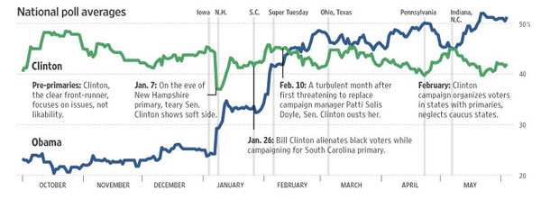
This Slate graph (via WSJ) of National Poll Averages shows how Clinton’s support never really varied but Obama’s continually rose. (Also see RealClearPolitics McCain vs Obama trendlines.)
2008-05-27
quikmaps.com is an easy to use & config Google-map making tool. Here’s a quickmap of all the HV stations carrying the HV weekly hour series:
2008-03-19
To demonstrate our WY-centric station carriage, mentioned in post prev, our graphics team has prepared this map:

That’s right, there’s a new toy in town, Google Charts: online generation of graphs, charts, and data-driven maps. Thanks, Jon, for telling me about it and making me waste my morn — you know I can’t resist to trying new tech. Or as Jon graphically points out:

2008-01-19
Was just looking at North and South Korea because I picked up David
Halbersham’s The Coldest Winter: America and the Korean War today and saw this:
Massive Baitoushan stratovolcano, also known as Changbaishan and by the Korean names of Baegdu or P’aektu-san, is a relatively unknown, but volcanologically significant volcano straddling the China/Korea border.
A 5-km-wide, 850-m-deep summit caldera is filled by scenic Lake Tianchi (Sky Lake). A large Korean-speaking population resides near the volcano on both sides of the border. The 60-km-diameter dominantly trachytic and rhyolitic volcano was constructed over the Changbaishan (Laoheidingzi) shield volcano. Satellitic cinder cones are aligned along a NNE trend. One of the world’s largest known Holocene explosive eruptions took place from Baitoushan about 1000 AD, depositing rhyolitic and trachytic tephra as far away as northern Japan and forming in part the present caldera. Four historical eruptions have been recorded since the 15th century.
View Larger Map
2007-10-25
KPBS-FM has made a Google Map for wildfire updates in the San Diego area. And here’s Los Angeles wildfire updates from the LA Times. Both are linked from the maps.google front.
2007-09-13
An beta vers of an NPR Station Coverage Map. Roll over transmitter icons and it shows the areas covered and signal strength.
2007-08-30
 Goggles, GoogleMaps flash Flight Sim (beta)– tres kewl.
via some velvet blog.
2007-07-09
Slate’s Explainer has the skinny on the fashion ins and outs of buying a good one that reps your clan, creed or splinter group. See the video.
The only time I was able to ever wear one was while actually skiing…while it was below zero. I even had (briefly) a neoprene model that worked rather well at 30 below but felt slimy inside after a few runs. (The skis wouldn’t work well anyway since it was too cold to create the micro-thin layer of melt water that you actually glide on). So, in a way, I’ve gotta hand it to these wild ‘n’ crazy guys with their AK-47s and a desire for anonymity/clan identity/scary-looking-motherf’erness. That is badass when the average high for July and August is 91 F. (But the humidity is low, my friend).
2007-03-14
Gotta see if I can actually answer all of these for my locale:
http://www.kk.org/helpwanted/archives/cat_the_big_here.php
Some are obvious, others quite challenging…or I just forgot. Is Helena at 3800 feet? Some you don’t have to answer if you’re landlocked.