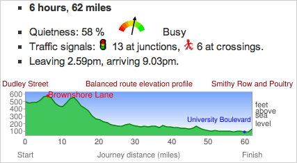
 CycleStreets: UK-wide Cycle Journey Planner and Photomap is a feature-rich route-planner for pedalers. Lotsa info and options, including a choice between the Fastest or Quietest route (or blend of both), an elevation map, an export in GPS format, and turn-by-turn directions w/ type of road (Quiet St, Cycle Track, Busy Rd, etc.).
They just released an iPhone app. Their web version’s in beta, and built on the OpenStreetMap project.
CycleStreets is a UK-wide cycle journey planner system, which lets you plan routes from A to B by bike. It is designed by cyclists, for cyclists, and caters for the needs of both confident and less confident cyclists.
Say you were pedaling from Wolverhampton and Nottingham (hey, I don’t name these places), here’s some of what CycleStreets tells you about your route:
